Around the year one thousand, the great events in the history of Europe took place in the scenario of the Reggio Apennines, and the protagonist of these events was the Countess Matilde di Canossa, who had placed the political and military center of her immense fiefdom here. Of that great power remain a large number of castles and churches that recall a period of strong political and religious passions.
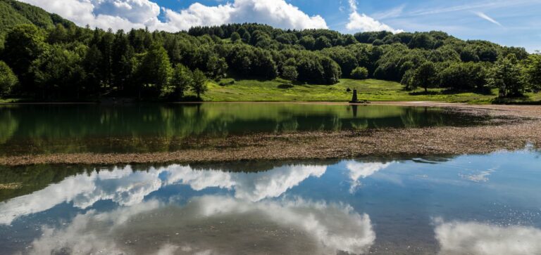
The Sentiero Matilde represents one of the strategic crossroads for hiking in the province of Reggio Emilia in the direction of the Apennine ridge and Tuscany. It is made up of a network of itineraries along the ancient roads of the Middle Ages thanks to which it is possible to relive the story of Matilda of Canossa by crossing the ancient places of her great fiefdom, which extended for a good part of the central-northern peninsula.
The path is fully marked and signposted. The horizontal signage is made up of painted red-white-red signs, while as vertical signage there are metal arrows along the entire route that indicate the close, intermediate and stage destinations. Furthermore, at the main points of the route there are rest areas with an overall information board.
The path leads from the cliff of Canossa to the small village of San Pellegrino in Alpe, a natural balcony over the Garfagnana, through castles, tower houses, ancient churches and villages set in an enchanting natural landscape. It consists of five stages plus the entrance link from Reggio Emilia, thanks to which it is possible to discover the great suggestion of the artistic and historical heritage left by the most important woman of the Middle Ages.
Citizen connection: from Reggio Emilia to Canossa
The “city ring road” begins on the southern outskirts of Reggio Emilia, immediately beyond the San Pellegrino bridge, which can be reached by taking the historic Viale Umberto I. It starts by following the cycle/pedestrian path of the Cròstolo stream, which runs alongside it on the left bank for about 6 km. Along the cycle/pedestrian path, you will find the Parco Fucini and the Parco delle Caprette, while the nature trail extends along the right bank of the stream. The Crostolo park includes places of monumental value such as the Palazzo Ducale di Rivalta, the Villa di Rivaltella and the Casino della Vasca (Vasca di Corbelli).
Continue up to Vezzano sul Crostolo, whose territory is dotted with a significant historical, cultural, landscape and environmental heritage. Of particular interest is the Church of San Martino, in whose southern elevation there is a sculpted architrave bearing the Canossa emblem. In the historic center some tower-houses dating back to the 15th century are still visible. From the center of Vezzano, skirting the base of the sandstone hill, you then reach the village of Castello di Canossa.
STAGE 1: Ciano – Casina
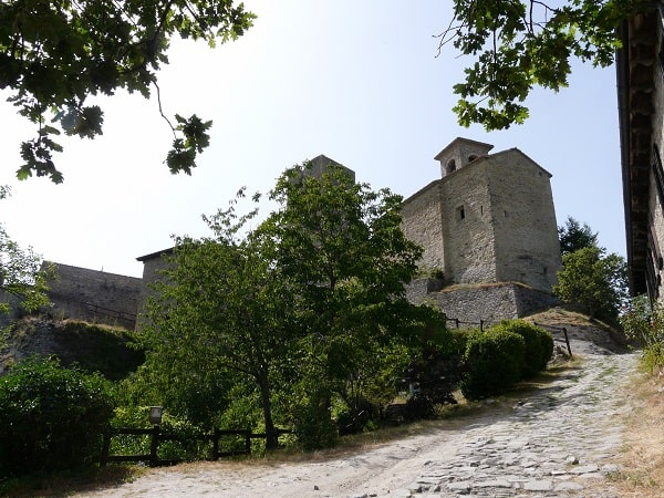
The Matilde Path starts from the railway station of Ciano d’Enza, capital of the municipality of Canossa. Following the signs, you reach Vico, a delightful village that partially retains the original urban structure despite the continuous alteration of the environmental characteristics. In particular, it has an interesting rustic with a seventeenth-century dovecote tower belonging to the Giovannini family. After passing the village of Vico, continue to the village and the Rossena Castle located on a reddish volcanic cliff from which it takes its name. The castle, perhaps the most beautiful and best preserved of all in the entire Matildic area, dominates an extraordinary panorama that embraces a large stretch of the plain and the Tuscan-Emilian Apennine ridge. The route continues towards the village of Riverzana, a small nucleus located on a hillock under the slopes of Canossa with a view of the valley of the Ferrari and Vico rivers.
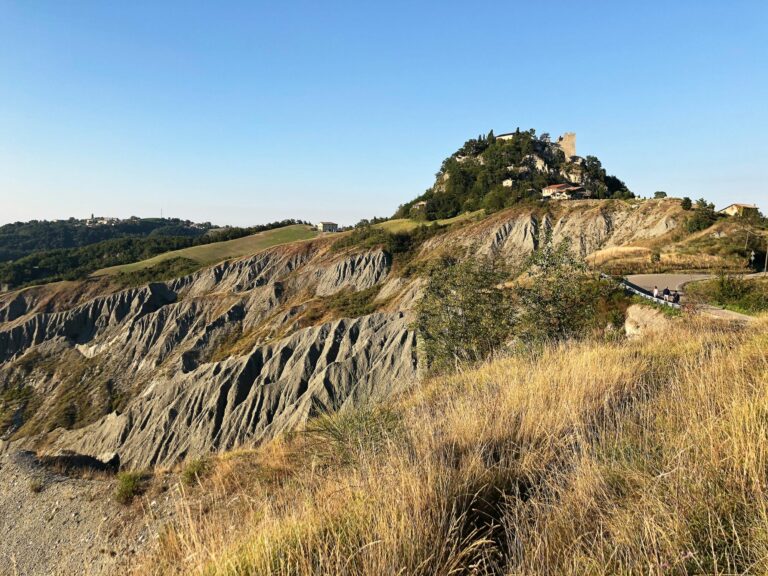
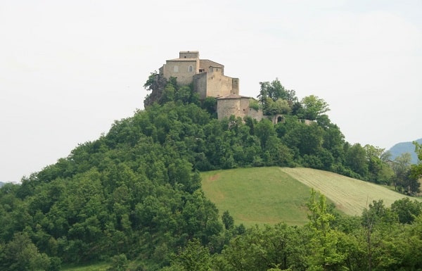
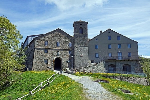
After passing the small nucleus of Riverzana, you reach the village and the ruins of the Castle of Canossa, which is known throughout the world for the event that occurred in the harsh winter of 1077, when the emperor Henry IV, as a pilgrim, waited for three days and three nights, before being received and forgiven by Pope Gregory VII, with the intercession of Matilda of Canossa. The Castle, surrounded by suggestive gullies that give the landscape an almost lunar appearance, currently houses the “Naborre Campanini” Museum. We then continue towards the village of Cavandola, a small group of houses located on the eastern slopes of Mount Tesa. From Cavandola you skirt the slopes of Mount Tesa up to Ceredolo dei Coppi, a village whose unique feature is the presence of very rich auspicious ashlars with sketched human faces. The next destination is Bergogno, a charming village among the most interesting in the Canossa area, which retains the main characteristics of the local late medieval architecture.
Leaving Bergogno, the route goes up to the town of Crocicchio. We recommend a digression to the nearby Pieve di S. Bartolomeo di Pavullo, an ancient church which has a beautiful Romanesque facade and of which we have written records since 980. From Crocicchio continue to the village of Monchio dei Ferri, or Monchio di Sarzano, important example of rural fortification constituted by the Corte dei Rossi. The itinerary continues up to the Castello di Sarzano, a fief of Matilde di Canossa located on the top of a hill that since ancient times stood in defense of the road that climbed from Reggio di Lombardia towards the passes for Tuscany. From Sarzano, the stage ends by descending a panoramic path that leads to Casina.
STAGE 2: Casina – Carpineti
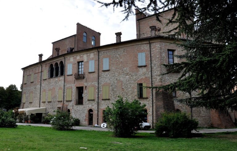
The second stage connects two “capitals” of the Terre di Canossa: the municipal capitals Casina and Carpineti. It starts from the Casina town hall in the direction of Marola and arrives at the Migliara church. The path then enters the woods arriving at the hamlets of Cà Brioni: Castello, a rural complex with an articulated layout probably referable to the 16th-17th century; and Ca’ Nova, a prestigious rural complex belonging to the Canovi family. From Ca’ Nova go up to the tallest houses of Marola and then descend and cross via Dante Alighieri reaching the Seminary-Abbey of Marola, built between 1076 and 1092 through the generosity of Countess Matilde di Canossa, as a demonstration of her gratitude towards of the hermit Giovanni da Marola, rewarded for having encouraged her to continue the fight against the emperor Henry IV. Marola is well known not only for its Romanesque abbey but also for its chestnut groves. From the seminary, proceed towards Cigarello, where you cross the other branch of the Sentiero Matilde which descends from Valcava and passes through the Croce di Petrella locality, whose main emergence of the nucleus, abandoned, consists of a valuable sixteenth-century building.
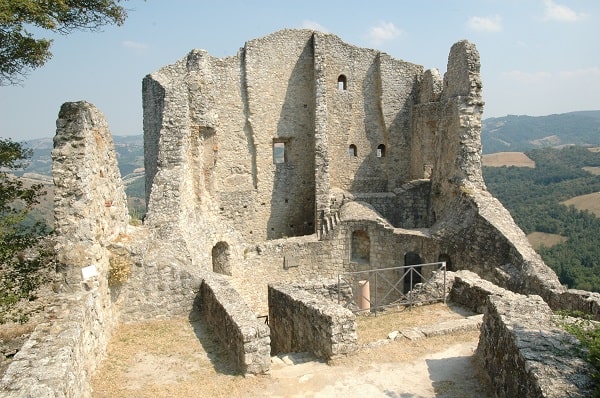
From Cigarello, where there is a complex divided into two characteristic tower-houses, proceed towards S. Donnino which runs along the Tresinaro. You enter the village passing alongside the cemetery and the church of medieval origin, which according to tradition was built by the Countess Matilde of Canossa. The path continues towards the village of Riana, a suggestive rural nucleus with tower houses, and from here a short detour allows you to reach the village of Regigno, a highly prestigious nucleus located on a hill to the left of the Riana stream. The path, on the other hand, continues towards the Carpineti Castle, or Carpineti Castle, located on the summit of Mount Antognano from which it dominates the Tresinaro and Secchia valleys, a few kilometers from the center of Carpineti. During the reign of Matilde, the fortress of Carpineti was further fortified and over time became the favorite residence of the countess, who spent long periods there administering her territories from within her highly secure and inaccessible walls. About four kilometers from the castle, the ancient Pieve di San Vitale is worth mentioning.
STAGE 3: Carpineti – Toano
Starting from Savognatica, you cross the Fosso delle Coste, the town of Cà Bazzoni and reach the rural village of Cogliolla, which stands in a particularly favorable position for visual inspection of the Secchia. After crossing the Ponte dell’Oca and the provincial road, the path climbs along the ancient “municipal road” which cuts through the open field crops up to Cavola. Located close to the Secchia valley floor, the town of Cavola is a very lively economic center thanks to various craft companies that keep traditions such as carpentry and stone work alive. There are two buildings of great architectural and artistic interest: the Parish Church of San Michele, which has remarkable stone decorations in the portal and side elevations; and the Oratory of the Madonna della Neve, with inside the seventeenth-century altar in inlaid wood, the work of Francesco Ceccati. Upstream of the Church of San Michele, the path branches off to the left along a cart track that reaches the village of Stiano, a rural nucleus on the slopes of Mount Croce where the ancient Ceccati house with its characteristic tower is of particular interest.
After Stiano, the path continues across the fields climbing up to the charming village of Manno, where the paved path, the courtyard and the 19th-century villa of the Ghirardini family, the church of S. Prospero and Paolo are still visible. The itinerary continues climbing up to the village of Castello di Toano and the Romanesque parish church of S. Maria in Castello, counted among the most significant monuments of Romanesque architecture in the Reggio Emilia area and among the oldest religious buildings in the Reggio diocese. The descent towards the Dolo stream takes place via the road of the village of Polcione which becomes a cart track and intercepts the Oratorio dei Prevedelli and the village of Frale.
STAGE 4: Toano – Gazzano
From Frale, continuing through cultivated fields and residues of ancient vineyards, you reach the Dolo stream at Villa Bonicelli, an ancient building, partially renovated, where the original typological characters are still visible in the remaining elevations. The path then continues towards the ancient thermal springs of Quara, formerly called the “Balneum Aquarium” and of which we have news in the mid-15th century. The itinerary continues towards Cadignano, in the municipality of Villa Minozzo, a village with ancient manor houses and an oratory from which you descend to the 17th-century humpback bridge.
From Cadignano you can follow two parallel routes: one on the Reggio bank (to the left of the Dolo stream) and one in the Modena area (on the right bank of the stream).
The Reggiana variant from Cadignano Borgo goes up to Campolungo and from here the locality of Calvello along a partially paved road. From Le Bore proceed towards Cà de’ Rossi intercepting the municipal road of Morsiano, an important village that extends on the extreme eastern slopes of Mount Penna, and after crossing the village continue towards Romanoro. You reach the ford on the Cervarolo stream and from here you go up through the woods until you reach Gazzano.
The Modenese variant from the Cadignano bridge runs alongside the Dolo stream intercepting interesting pools of water and reaches the bed of the historic landslide of Valoria-Rio Rumaggio. Go up along it as far as C. Percigolo, and then continue up to Romanoro, where you can admire the beautiful Church of S. Scolastica. From Romanoro you reach the village of Montale and the nearby village of Panigale, take the roadway which, after a short climb, reaches the Strada del Tracciolino. Along the way there are spectacular sandstone walls sculpted by the waters; the bridges and finally the dam are works of great architectural interest. Along the route, the junction branches off for the historic Matilda town of Frassinoro, passing through Rovolo, a village of considerable architectural interest. Returning along the Strada del Tracciolino, you reach the church and the village of Gazzano.
STAGE 5: Gazzano – San Pellegrino
It is the final stage, decidedly mountainous, spectacular and demanding. Following the paved road that starts from Gazzano, you arrive at Le Pere Storte, a village made up of a manor complex and farmhouses. After the last houses, continue along a cart track going up to Case Farioli and Fontanaluccia, a village of ancient origins famous for its chestnut groves. After fording the Rio Rumale, you reach La Teggia, from which a gradual climb, crossing forage and beech woods, leads to Mount Roncadello and the village below.
From Roncadello you arrive at the place known as Colle del Morto. From here the route intercepts the paved road that leads to S. Geminiano several times. Once you reach Passo delle Radici, cross the state road and take the paved road that reaches the first houses downstream of the village of San Pellegrino in Alpe with a unique view of the Tuscan side.
There is also a “summer variant” of this last stage, a name that depends on the fact that it is not recommended to be covered in the bad season.
From the church of Gazzano go through the village and reach the Fontana della Pila, with tables and a picnic area. Continue, passing a rocky ridge from which the view opens onto the narrows of the Dolo, dominated by the ruin of the Torre dell’Amorotto, a part of the ancient Castello delle Scalelle. At the beginning of the 16th century the fortress was occupied by Domenico d’Amorotto from whom it took its name. The path then continues to Civago, the last inhabited center that precedes some of the most interesting areas of woods and high-altitude grasslands of the Reggio ridge: the Abetina Reale and Monte Prado. Civago offers a series of thematic trails that allow you to observe pastures and chestnut groves with still ancient artifacts: fountains, tegge, metati, majesty, dry stone walls. From Piazza di Civago you can then reach the Case di Civago.
The route goes around the ruins of the Case del Dolo and reaches the Rifugio San Leonardo, rebuilt on the site of the ancient hospitale for pilgrims, whose existence has already been documented since the 12th century. Immediately beyond, you ford the Dolo and Riaccio delle Forbici, climb up the ancient Via delle Forbici and reach the Passo delle Forbici.
For more information visit the official web site of Sentiero Matilde.
AGRITURISMO IL BRUGNOLO
Welcome to il Brugnolo
If you’re looking for completely independent apartments surrounded by greenery you really are in the right place here!
In fact, Brugnolo is immersed in the green nature of the Emilian countryside. For your relaxation, for that of your children, and again for the runs of your 4-legged friends, you will have 6000 square meters of park at your disposal!